Xastir
Xastir: the APRS client
Xastir is one of the most complete and long-standing APRS clients available on Linux/Unix systems.
The name stands for X Amateur Station Tracking and Information Reporting, and it was originally developed by Frank Giannandrea, KC2GJS, as a graphical client for the X Window System. Born in the open-source world, it is designed to provide an “operational” view of APRS—not just as a tracking system, but as a true real-time data communication network. Unlike purely web-based tools, Xastir allows integration of traffic coming from both the Internet and radio, supports beacon transmission, message sending, and the construction of a full APRS station.
When connected to a TNC—either hardware or software—it can decode all communications within range of your antennas. The ability to integrate data from the global APRS-IS network adds an extra layer of capability: once configured, Xastir will display the same stations visible on web services like aprs.fi, but with far greater interaction possibilities.
After installation (typically from your distribution’s repositories), the first step is to create a connection to the APRS-IS network.
Inside Xastir, everything is handled through the concept of interfaces: you can have several, but the one relevant here is the internet server interface.
When configuring it, you are asked which server to connect to; the most common value is rotate.aprs2.net, which is actually a load-balanced entry point to multiple servers worldwide. The port is usually 14580.
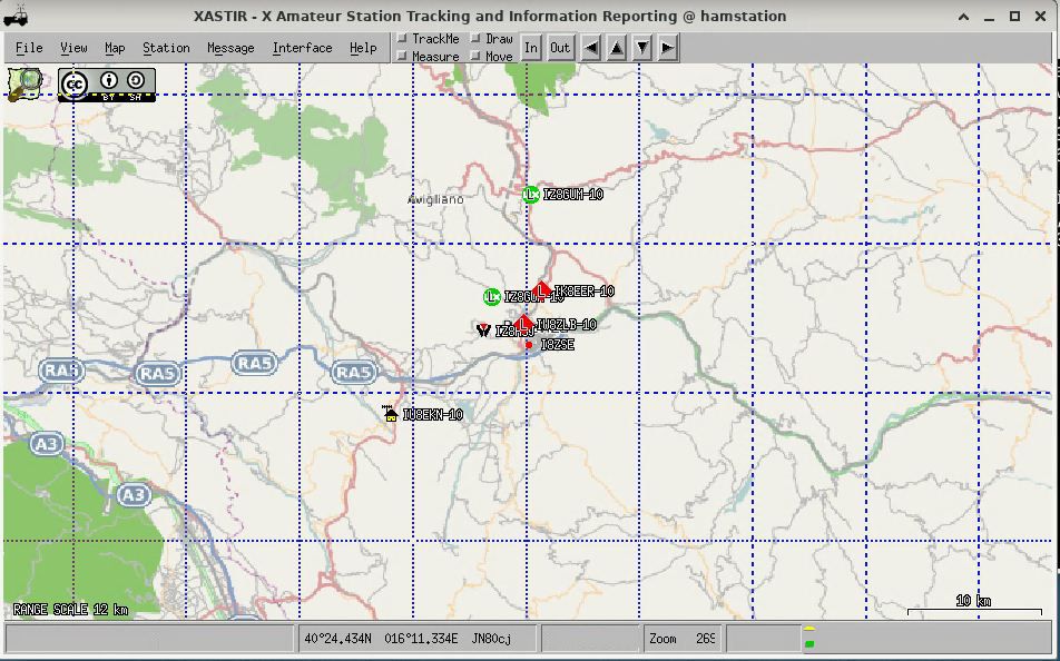
It is essential to define a filter, which limits the amount of data downloaded from the Internet: m/300 selects stations within a 300 km radius of your configured station location; alternatively, r/<lat>/<long>/100 filters stations within 100 km of the specified coordinates in decimal degrees (e.g. r/40.63/15.80/100, centered on Potenza).
Another required parameter is the APRS-IS passcode, which is derived from the callsign using a public algorithm. It is required if you want to transmit data as well as receive it. Xastir includes a built-in tool called callpass to compute it, but online generators also exist. Without a passcode you can still use Xastir in receive-only mode, effectively as a “local window” into aprs.fi.
One of the key differences compared to a web service is traffic management.
Without filters, the APRS-IS network is massive and you would receive global data, making the display chaotic. For this reason, a geographic filter is used: for example, you can set a radius of a few dozen or hundred kilometers centered on your location. This way, Xastir shows only what is relevant to your local activity, making the map much more readable and useful.
Once the connection is active, the main Xastir window starts populating: stations, objects, digipeaters, and tracks begin to appear. Here the real difference from web services emerges: you are not just observing, but working within an interactive system. You can click on a station to view details, follow its path, send APRS messages, and—if transmission is configured—also appear yourself on the network.
To be visible to others (and therefore also on services like aprs.fi), you must configure your station parameters: geographic position, APRS symbol, and a short descriptive comment.
When you start sending beacons via APRS-IS, your data is distributed across the global network and collected by various online services.
One often overlooked aspect is map handling. Xastir can run without maps, but it becomes far more useful when you load mapping data (for example from OpenStreetMap-derived sources or online tiles). These can be selected from the menu. Some map sources require an API key, which must be requested from the service provider.
With daily use, it becomes clear that Xastir offers much more than simple visualization. You can monitor real-time traffic, analyze the local network, verify digipeater coverage, send direct messages, and even integrate RF operations via a TNC or audio modem. In that case, Xastir can also act as an iGate, bridging the local radio network with the Internet.
Once properly configured with APRS-IS connectivity, geographic filtering, and station parameters, Xastir becomes a powerful and complete tool, combining visualization, analysis, and operational capability in a single interface.
Post Comment